California must co-manage drought and flooding at the same time by Peter Schurmann
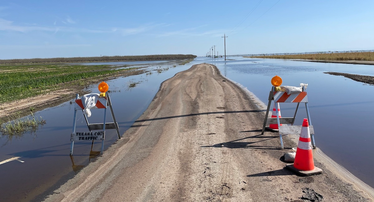
Editor’s Note: The series of devastating storms that brought California out of its decade long drought this past winter also left parts of the state underwater. In the San Joaquin Valley, the flooding has led to the reemergence of Tulare Lake, once the largest freshwater body west of the Mississippi. The onset of Spring and warming weather now threaten even more potentially catastrophic floods as a historic snowpack in the Southern Sierras begins to melt, jeopardizing local farm working communities and one of California’s largest agricultural regions. Climate scientist Daniel Swain with the Institute of the Environment and Sustainability at the University of California, Los Angeles says this “whiplash” between prolonged dry spells and more intense rain will become an increasing feature of California’s climate as the planet warms and that the state needs to do more to prepare. (Above image: Tulare Lake floodwaters in April. Credit Dan Brekke via Flickr)
Were the torrential rains this past winter a predictor of what’s to come for California?
California is no stranger to really wet winters. There’s a long history of years that are much wetter than average. But we expect that feature to be an increasingly prominent piece of California climate in a warming world. On the wet side, we expect to see more extremely wet winters and more intense and wetter individual storms as well.
What does that signal in terms of drought conditions going forward? Are we in the clear here in California?
At this point the amount of global warming that’s already occurred has increased the intensity of extreme precipitation events in California by somewhere about 5% and 15%. It does not mean that California’s average precipitation has increased by this amount. In fact, it has not really changed at all. If anything, it has slightly decreased. But this whiplash is one of the signatures of California’s climate in a warming world. Some parts of the state – especially in the central and northern regions – have experienced both their wettest and their driest years in over a century of record keeping in the past 10 years.
So what you’re saying is that the amount of overall rain California gets may not change but that when it does rain we can expect those events to be more intense. Is that right?
Yes, which of course increases flood risks. You could have 20 inches of rain over the course of a year and that is a very average year. You could have 20 inches of rain in 3 weeks and you’re in a flood emergency. So how quickly it falls very much matters. It’s also true that the rest of the time it may be getting drier.
How does the state plan for these extremes of longer dry spells and more extreme and potentially destructive flooding?
Well, you can’t myopically focus on water scarcity or on flood. You have to be thinking about both at the same time, co-managing risks of drought and flood. You really cannot separate those two things. And to our detriment that is how we’ve managed floods and droughts historically in California, dealing with them as completely separate problems… We need to stop doing that.
What does co-managing risks of drought and flood look like on the ground?
It means things like strategic groundwater recharge, shunting potentially dangerous flood waters to minimize damage in the short term and give us benefits in the long term. It might be a matter of building canals and conduits. Some people are proposing that we build more dams. The reality is we’ve already dammed up all the big rivers. And while dams are great for storing water, in a warming climate they become an extreme liability.
The floods have led to the reemergence of Tulare Lake and have inundated local farming communities in the Central Valley. With more and potentially worse flooding to come as the Sierra snow melts, what are your concerns for the region?
I am not sure it will be physically or economically viable to rapidly pump the water out of the Tulare Basin once it floods deeply. And if there aren’t realistic means to get the water out quickly…a lot of contamination is going to happen. This won’t be a pristine, freshwater body. It will be full of fertilizer, pesticides, sewage and any number of commercial chemicals that get into floodwaters. And the problem is it will sit there and percolate for a long time… There is a big chunk of the San Joaquin Valley whose future is very much in question right now in terms of what might unfold in the next few weeks.
What is your sense of how actively California officials are preparing for this? It seems much of it is being left to local counties and even residents to figure out.
It absolutely is, even to the extreme point where individual large landowners are making decisions that affect tens of thousands of people who actually live there, unilaterally. Very undemocratically, one might suggest. In some cases, one person gets to make that decision out of self-interest about what will harm my land the least… and often it is in direct opposition to what would harm tens of thousands of people because if my land doesn’t flood it increases the likelihood that someone else’s land will. The power dynamics here are very asymmetric.
This almost feels like a microcosm of the larger issue of climate change. We know the disaster is coming yet we do little or nothing to prepare and leave the most vulnerable to fend for themselves.
The reason the southern San Joaquin Valley is more of a mess than other places is in part because so much of the region is controlled by individual, massive agricultural landowners… they have an outsize degree of control relative to even state or federal agencies. So, there is not a great deal of oversight. If you own a huge amount of land, you have a great deal of power right now. That is not as true elsewhere, where you have a patchwork of ownership and where the state has greater control, such as in the northern parts of the valley. It’s still a highly vulnerable region to flooding, but the level of organization and state intervention is noticeably higher. Whereas it really is the wild west in the Tulare Lake Basin and San Joaquin Valley.
Climate models predict California may enter an El Niño weather pattern later this year. What does that mean in terms of our current challenges?
There is about an 80% chance that it will happen. We don’t currently know how strong it will be… there is a 40% to 50% chance that it will be a strong event. And the relationship between California’s precipitation and a strong El Niño is pretty robust, especially in Central and Southern California. Meaning that if these odds play out, it increases the odds of another wetter than usual winter next year. If we go into next winter with ongoing flooding in the Tulare Basin… that will play into this conversation about its long-term fate.